


Page
DAACS
Learn how archaeologists are using Internet technologies to foster comparative research and scholarly collaboration.
Plantation Survey
Introduction
The Plantation Survey is an example of landscape archaeology. In the landscape approach, "the mountain is the site." In other words, the entire landscape surface, and what lies beneath it, provide valuable clues about past human activity. To take advantage of them, we investigate not only scatters of artifacts -- "archaeological sites" in the traditional sense -- but also the patches in between. The patches contain road traces, erosion gullies, rock alignments, check dams, sediment deposits, and soil horizons, all of which once formed the context in which past land use took place. Together the scatters and the patches comprise a cumulative record of land use history that in many ways is more complete than the documentary record left us by Thomas Jefferson.
Methods
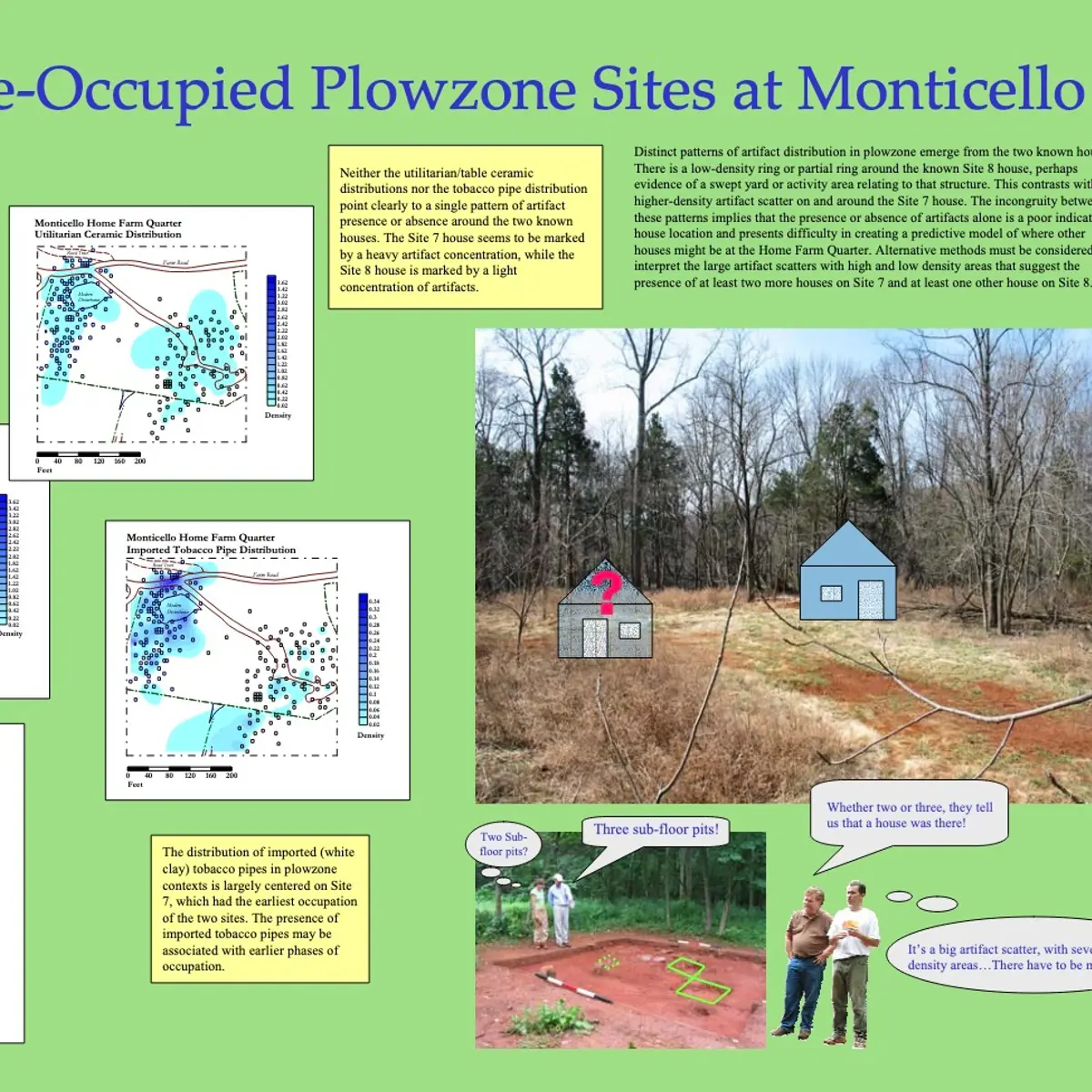
Deciphering the landscape record requires fieldwork at different spatial scales using different techniques.
Digital photogrammetry for the acquisition of high-resolution topographic data, featured in the map on this page.
Totalstation mapping of surface landscape features, for example the erosion gullies whose bottoms appear as thin blue lines on the map.
Shovel test pit (STP) excavation and metal detection, on a 40-foot grid, to locate artifact scatters and estimate their size.
Jefferson-period sites located to date are numbered on the map. Click the numbered squares for more information.
Excavation of 5-foot quadrats, 5-20 feet apart, to understand the spatial structure of individual sites. So far our work with internal site structure has concentrated on Sites 6, 7, and 8, which contain a complex sequence of temporally overlapping occupation by overseers and slaves from 1750 to 1840.
Core sampling and test-pit excavation into soil horizons and stratified sediment desposits, aimed at dating landscape features and reconstructing past ecological processes.
To date, we have excavated over 16,000 STPs on the Monticello Home Farm, revealing over 40 domestic, agricultural, pre-contact, and post-Jefferson sites. The dots on the map represents individual STPs in the area covered by the survey so far. Clearly, there are many more sites to be found.
Research Themes
The half-century during which Jefferson owned Monticello was an ecological and social watershed in the history of the Chesapeake region. The Plantation Survey is designed to elucidate the intertwined ecological and social dynamics that shaped the lives of all of Monticello's residents during this period. Tobacco was the foundation of commercial agriculture across the Chesapeake during the 17th and most of the 18th century. However, as the 18th century drew to a close, changes in trans-Atlantic markets encouraged slave owners to abandon tobacco in favor of wheat. Jefferson was no exception and in the 1790's he began an aggressive program of agricultural diversification at Monticello.
Since the 17th century, tobacco had been grown using hoes in a long-fallow system of field rotation. Wheat cultivation required plowing, draft animals, fodder crops, permanent fields, crop rotations, and fertilizers. The Plantation Survey aims to chart the way in which the transition was undertaken at Monticello, along with its ecological consequences. For example, how were field locations and layouts engineered to accommodate new crops? How did vegetation change? How were erosion rates affected by the replacement of hoeing by plowing? How did these environmental changes impact the daily experience of Monticello's plantation workers?
We are equally interested in the social consequences of economic diversification. Agricultural diversification radically altered the work routines of Monticello's enslaved workers. The variety of different tasks that needed to be done increased. It became more difficult for slave owners to coerce work from enslaved laborers by assembling them in large gangs at a single place, where they could be easily watched by an overseer. In theory, this shift could have lead to changes in the strategies slave owners used to manage slaves, and the strategies slaves employed to resist the deleterious effects of slavery on the well being of their families. Can we see the physical traces of this dynamic in changes in slave settlement and living conditions? If diversification increased the costs of surveillance, did slave owners rely on it less? For example, such a change might be evident in greater distance between the houses of slaves and overseers.
Yet another set of questions revolves around the social dynamics of the slave community. The majority of enslaved Africans forcibly imported into the Chesapeake arrived before the middle of the 18th century. By the time of the Revolution, the vast majority of the slaves in the region and at Monticello were native born. After the Revolution, the generational depth and lateral extent of kin relationships among slaves increased further. How did these developmnents affect slave lifeways? Did they increase slaves's ability to assemble large kin-bonded social coalitions, that might have been more effective in resisting slavery and result in marginal improvements in living conditions?
Promising Results
Although a vast amount of the Monticello landscape remains to be covered by the Plantation Survey, preliminary findings reveal important changes in the pattern of slave settlement and land use during Jefferson's tenure at Monticello.
We have located rock alignments in the Paw Paw and Slate Branch drainages on Monticello Mountain that impound layers of eroded sediments. Multiple lines of evidence indicate the alignments were built to mitigate the effects of erosion on streams that were the source of drinking water. The layers contain a pollen record of initial forest clearance, agricultural diversification, and reforestation of Monticello Mountain. The sediment and the alignments document a quantum increase in erosion rates that accompanied diversification.
The Survey has also revealed important shifts in the pattern of slave domestic settlement that seem to date to the 1790's. Mean distance among individual slave houses appears to have increased. So does the mean distance from slave houses to the overseer's house. Just how these changes relate to African American kin networks and agricultural diversification are topic of current research.
Learn how archaeologists are using Internet technologies to foster comparative research and scholarly collaboration.
Read detail reports about field projects and analytical methods of Monticello's Department of Archaeology.
The summer Monticello-UVA Field School offers a hands-on introduction to basic excavation, recording, and laboratory techniques in archaeology.
Next page in
Archaeology
/Recent Research
